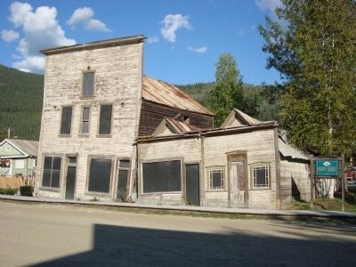
[English] In Dawson City’s history, permafrost ranks second only to fire as the bane of buildings. These three structures, dating from 1901, illustrate what can happen when heated buildings are placed on frozen ground; the frost melts, mixing water . . . — — Map (db m49305) HM
The Arctic Brotherhood was a fraternal organization formed onboard the steamer Seattle while anchored at Skagway. In 1901 Camp #4 Dawson City built a fraternity hall, known as the Arctic Brotherhood Hall to host their meetings as well as uphold . . . — — Map (db m49348) HM
[English:]
The BNA, which opened Dawson City’s first bank in a tent in 1898, moved into these premises in 1899. By providing the essential services of assaying, buying and shipping gold, it helped integrate the local currency of dust and nuggets . . . — — Map (db m44857) HM
[English] This building stands as a testament to the way frontier businesses changed and adapted to new realities. It began life in 1899 as the two storey Great Northern Hotel, to service the needs of a rapidly growing population. By 1907, as the . . . — — Map (db m49304) HM
[English] The Dawson Daily News moved into this building in 1910, the sole survivor among 7 gold rush newspapers. It provided Dawson City with a window to the outside world and remained a profitable business until the early 1920s. Thereafter, it . . . — — Map (db m49301) HM
[English:]
The names Robert Henderson, Skookum Jim, Tagish Charlie and George Carmack are inextricably linked to the discovery of gold on Bonanza Creek. Henderson was first to systematically explore the gold bearing potential of the region, only . . . — — Map (db m44702) HM
[English] Built for Dr. Brown, a dentist, in 1902, this attractive little bungalow was tangible proof that affluent residents had confidence in the future of Dawson City and were willing to put down roots. While this may have been somewhat . . . — — Map (db m49345) HM
[English] Like other grocers at the turn of the century, Harrington provided a cosmopolitan clientele with every conceivable foodstuff, from beans to truffles. This was made possible by the coincidence of improved transportation systems with new . . . — — Map (db m49303) HM
[English] Built in 1899, this warehouse was taken over by the Klondike Thawing Machine Company 1n 1913. The growing hardware company was it the process of buying out other firms and expanding its line of goods even as Klondike gold claims were . . . — — Map (db m49302) HM
[English] This fine two storey house, built in 1901, was owned by Henry C. Macaulay, Dawson City’s first mayor. Subsequently, it housed such affluent individuals as a merchant, a Territorial Commissioner, a surveyor, and senior management of the . . . — — Map (db m49343) HM
While this building dates from 1899, it did not become Mme. Tremblay’s, a dry goods and novelty shop, until 1913. Émillie Tremblay had first come to the territory as a young French Canadian bride in 1895 with her husband Jack. After 15 years on . . . — — Map (db m44933) HM
[English] This handsome residence was built in 1902 for the commanding officer of the North West Mounted Police. It lent dignity, authority and a degree of permanence to the presence of law and order in Dawson City. While the police presence was . . . — — Map (db m49341) HM
[English] One of the complex of four warehouses that covered an entire city block in 1898, this and numerous other warehoused like it provided the life blood of Dawson City. For four months a year, the river was open for shipping and in the ensuing . . . — — Map (db m49346) HM
[English:]
“Arizona” Charlie Meadows, showman and self-made heroic figure built a lavish structure in 1899 to prospect gold directly from the miner’s pokes. Hugely successful over its first winter, the theatre offered vaudeville acts, . . . — — Map (db m44890) HM
[English:]
Prime Minister Laurier himself recognized the need to link the Klondike with the rest of the country. In 1900, he urged that the building of a Post Office “...be proceeded with at once.” As the first substantial building . . . — — Map (db m44936) HM
Credited with saving many lives, Father Judge was one of the true heroes of the Klondike, serving the area from May 1897 until his death January 16, 1899. In this short period he built St. Mary’s Hospital, a church and residences, doing much of the . . . — — Map (db m70916) HM
English:
Within 5 years of Robert Service's departure in 1912, the local press referred to his rented cabin as a “shrine”. It became Yukon’s foremost tourist attraction virtually from the day it was abandoned. Maintained, . . . — — Map (db m42695) HM
[English:]
Opened as a boarding house and laundry in 1902, the building was taken over by Mathilde “Ruby” Scott in 1935. For over 27 years, this former Paris Madame operated a brothel here, finding a ready clientele in the seasonal . . . — — Map (db m44887) HM
[English] This substantial Presbyterian Church was a reflection of the prosperity and commitment of the congregation it served. Erected in 1901, it boasted a pipe organ and carved oak pews that could accommodate 600. The church bore the . . . — — Map (db m49307) HM
[English:] This structure, built in 1900, is all that remains of a larger complex that included a warehouse and dock. At the time of the gold rush and for years afterwards, the riverfront was the transition point between Dawson City and the rest of . . . — — Map (db m44859) HM
“What fools we mortals be.”
About 150 people, “many of whom were ladies”, attended the first formal gathering to see the midnight sun on June 21, 1899. Weary mountaineers were greeted with a selection of nuts, candies and . . . — — Map (db m44762) HM
Dedicated to the Klondike Gold Miners past, present and future in recognition of their contributions to Dawson City and the Klondike Region.
In 1896, gold was discovered on Rabbit Creek (later known as Bonanza Creek) by Skookum Jim, George Carmack . . . — — Map (db m49349) HM
West Dawson was settled c. 1899 by people wanting to avoid overcrowding and typhoid outbreaks in Dawson. Farms also became established and later, as mining in the Sixtymile area increased, a link with Dawson became necessary. In 1902 a ferry guided . . . — — Map (db m44711) HM
[English] When it was built in the fall of 1898, the Binet Block stood at the southern end of the business district extending north to King Street. A two-storey log building with a facade of milled lumber, it was typical of commercial structures . . . — — Map (db m49306) HM
The Yukon Saw Mill Company was one of the first to cut timber in the Klondike, registering its first timber lease in March of 1898. At its peak, the company’s machine shop was the largest north of Vancouver, and its lumberyard stretched over three . . . — — Map (db m44761) HM